mcp-server-proj MCP server
About
MCP Server PROJ (cartographic projections and coordinate transformations )
Details
- Author
- radial-hks
- Downloads
- 234
- Categories
- Other
Jump to
- Two coordinate transformation tools provided.
- Supports EPSG, WKT, and Proj format input.
- Accepts source CRS, target CRS, and coordinate arrays.
- Lists all supported CRS formats with detailed examples.
- Configurable for Claude Desktop on macOS and Windows.
- Debuggable via the MCP Inspector.

Setting up with Highlight
This MCP is not yet compatible with Highlight’s one-click setup. However, you can still use it with Highlight by following these steps:
- Download and install Highlight from highlightai.com/download
- Navigate to the plugins tab and select "Add Custom Plugin"
-
Configure the plugin with the settings below
Plugin Name
mcp-server-proj MCP serverCommand (node, npx, python, etc.)Please refer to the README for specific instructions on how to obtain API keys or other required environment variables.
- Enable "Start Automatically" if you want the plugin to start when Highlight launches





From the repository
Install and run the server using uvx mcp-server-proj (published) or uv pointing to a local copy (development). Configure the server in your MCP client’s JSON configuration file (e.g., Claude Desktop). The server exposes two tools: transform-coordinates and list-supported-crs.
Claude Desktop / Cursor
Paste into your MCP client config file to install this server.
{
    "mcpServers": {
        "mcp-server-proj mcp server": {
            "mcp-server-proj": {
                "command": "uv",
                "args": [
                    "--directory",
                    "E:\\Code\\PythonDir\\MCP\\mcp-server-proj",
                    "run",
                    "mcp-server-proj"
                ]
            }
        }
    }
}McpServers
{
    "mcp-server-proj": {
        "command": "uv",
        "args": [
            "--directory",
            "E:\\Code\\PythonDir\\MCP\\mcp-server-proj",
            "run",
            "mcp-server-proj"
        ]
    }
}
mcp-server-proj MCP server
MCP Server PROJ (cartographic projections and coordinate transformations)
Tools
The server implements two coordinate transformation tools:
1. transform-coordinates
- Transforms coordinates between different coordinate systems
- Supports the following coordinate system formats:
- EPSG codes (e.g., EPSG:4326 for WGS84)
- WKT format
- Proj format
- Required input parameters:
- source_crs: Source coordinate system
- target_crs: Target coordinate system
- coordinates: Array of points with x, y values
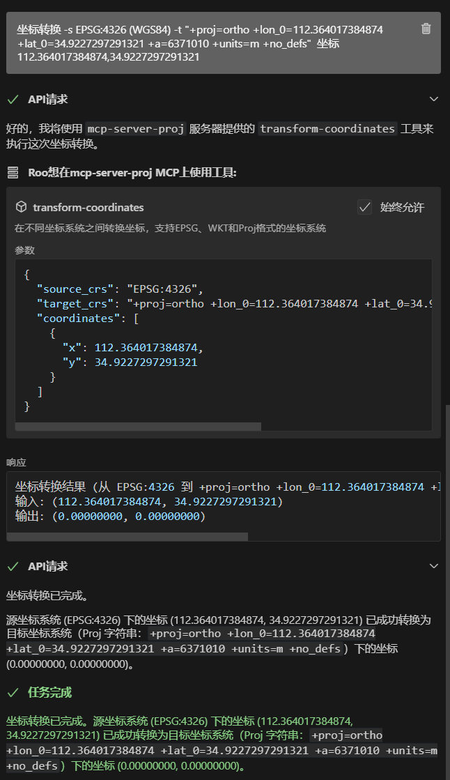
Example: Transform from WGS84 (EPSG:4326) to Orthographic projection
   Input:

   - source_crs: EPSG:4326

   - target_crs: +proj=ortho +lon_0=112.364017384874 +lat_0=34.9227297291321 +a=6371010 +units=m +no_defs

   - coordinates: [112.364017384874, 34.9227297291321]


   Output:

   - transformed coordinates: [0.00000000, 0.00000000]
2. list-supported-crs
- Lists all supported coordinate system formats with examples
- Provides detailed examples for:
- EPSG code format
- WKT format for geographic and projected coordinate systems
- Proj format
Configuration
Claude Desktop
On MacOS: ~/Library/Application\ Support/Claude/claude_desktop_config.json
On Windows: %APPDATA%/Claude/claude_desktop_config.json
<details>
<summary>Development/Unpublished Servers Configuration</summary>
{
  "mcpServers": {
    "mcp-server-proj": {
      "command": "uv",
      "args": [
        "--directory",
        "E:\\Code\\PythonDir\\MCP\\mcp-server-proj",
        "run",
        "mcp-server-proj"
      ]
    }
  }
}
<details>
<summary>Published Servers Configuration</summary>
{
  "mcpServers": {
    "mcp-server-proj": {
      "command": "uvx",
      "args": [
        "mcp-server-proj"
      ]
    }
  }
}
Debugging
Since MCP servers run over stdio, debugging can be challenging. For the best debugging
experience, we strongly recommend using the MCP Inspector.
You can launch the MCP Inspector via npm with this command:
npx @modelcontextprotocol/inspector uv --directory E:\Code\PythonDir\MCP\mcp-server-proj run mcp-server-proj
Upon launching, the Inspector will display a URL that you can access in your browser to begin debugging.
Coordinate System Information
1. EPSG (Coordinate System Unique Codes)
EPSG codes are unique identifiers for geographic and projected coordinate systems, commonly used in GIS software and programming libraries. Here are some common EPSG codes and their corresponding coordinate systems: - EPSG:4326: WGS84 Geographic Coordinate System (GPS standard) - EPSG:3857: Web Mercator Projection (used by Google Maps, AutoNavi Maps)2. WKT (Well-Known Text Format)
WKT (Well-Known Text) is a human-readable coordinate system description format, widely used in GIS software and databases. Here are typical WKT structures: - Geographic Coordinate System (GEOGCS)GEOGCS["WGS 84",
DATUM["WGS_1984",
SPHEROID["WGS 84",6378137,298.257223563]],
PRIMEM["Greenwich",0],
UNIT["degree",0.0174532925199433]]
PROJCS["WGS 84 / UTM zone 50N",
  GEOGCS["WGS 84",...],
  PROJECTION["Transverse_Mercator"],
  PARAMETER["latitude_of_origin",0],
  PARAMETER["central_meridian",117],
  UNIT["metre",1]]
3. Proj (Concise Projection Parameter Expression)
Proj is a concise projection parameter expression format, commonly used in proj4 library and command-line tools. Here are typical Proj syntax examples:WGS84:
+proj=longlat +datum=WGS84 +no_defs +type=crs
Web Mercator Projection:
+proj=merc +a=6378137 +b=6378137 +lat_ts=0 +lon_0=0 +x_0=0 +y_0=0 +k=1 +units=m +no_defs
References
For more information about coordinate systems, visit: https://epsg.io/ If you're interested in JavaScript implementation of coordinate transformations, check out: https://github.com/proj4js/proj4jsSign in to leave a review
Use Google, GitHub, or an email account so ratings stay tied to real people.
No reviews posted yet.